Tuesday, November 25, 2008

Brahmagiri


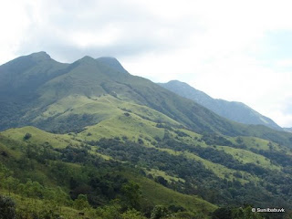
Several attempts over a period of 6 months turned to be fruitful as we were able to secure the permission from the Forest Department for a trek to Brahmagiri, a peak located in South western part of the Coorg District, Karnataka. A maximum of two teams are allowed over a weekend.

The team consisted of seven members. Anirudh, Narayan, Pramod, Rajesh, Shankar, Sandeep and myself. There were no beginners in the team as all had some sort of trekking experience.

A huge amount had to be forked out to the Forest Dept. for gaining entry into the forest. We were charged entry, trekking, accommodation, guide, maintenance fees and what not. The Office is located in Srimangala town. The starting point of the trek is Irupu falls which is 12 kms away. A decision to walk was made instead of wasting time waiting for the bus. An hour and a half later we were in the forest Dept. check post near Irupu falls. We were forced to wait for more than an hour by the guide who said another team has to come. Finally we were able to convince him and started our walk without the other team.

The weather which plays a vital role in case of treks was very cooperative. It was cloudy throughout the day and pleasant. Our first stop was Narimalai Forest Guest House after a two and a half hour walk from Irupu Falls. We found no surprises enroute though the Dept. officials said we would find a lot of elephants. We had actually planned to go to Munikal caves and Narimalai hills on Day 1 and head to Brahmagiri on Day 2. The guide insisted on heading to Brahmagiri peak on Day 1. So, we had little option. We quickly finished our lunch in the Guest house which was carried by us. The rucksacks were dumped in the Guest House and we proceeded towards the peak which takes two hours.

I was the last person walking. The guide who was leading the team suddenly started running back. I was a little confused as I didn’t realize what was happening. We heard movements in the valley which was on our right. There were elephants. The trees obstructed the view of the elephants. We were all ready to run just in case the elephants decide to turn nasty. Luckily they all moved away from us. Unluckily we were not able to spot them clearly. The team proceeded further towards the peak. The peak was visible from a distance. It looked like a normal one. It was indeed deceiving. The last leg was very steep, almost at an angle of 75 to 80 degrees. The climb was extra strenuous. Once we reached the top, as usual it was heaven. A never ending range of forests could be seen from the top in all directions. Another significance of the Brahmagiri peak is that one side of it falls in Karnataka territory and the other side falls into Kerala territory. The boundary lines of the two states are clearly visible even from a long distance.


While we were heading back in the same route which we took, a herd of elephants were spotted in the same valley where we failed to see. Quickly a few photo shoots were made and then silently we took a deviation from the original route to the guest house. A few hundred meters later a solo elephant was spotted which was standing in the open grasslands.

Another deviation was inevitable. A ten minute walk would have taken us to the guest house. But, we ended up walking three times the distance. Visibility was reducing every minute due to the formation of mist. Finally we made it to the guest house. The other team had reached the Guest house by then. They never made to the peak. Had we waited for them, we would also have missed it for sure. We barely slept in the night as it was very cold.


Day 2 morning, Munikal caves was the first spot we visited. The lazy guides decided to take both the teams together which none of our team members liked. Spotting wild life was next to impossible because of the constant noise made by the other team. An hour’s walk later we reached the caves. The place is littered with a lot of huge boulders. Nowhere else will you find so many boulders. It’s a wonder as to how they were formed and accumulated in just one place. Locals believe that one Muni resided in these caves and that is how it earned its name. Muni(saint), kal (rock). The Muni had built a small house for himself in those caves, of course abandoned now.


We headed towards the Forest Guest house and then proceeded towards Narimalai Hills. The guide asked us to go on our own. We started our approach to Narimalai. It took a little over 45 minutes to reach the top. From the peak we could almost see the entire Brahmagiri range. It was almost in the centre and in an equally elevated position. Never ending grasslands on the hill locks was a good sight with patches of trees in the valleys. A water fall near the Guest house was visible from the peak which was inaccessible. In a land of green a white line in a corner was making all the difference.

As soon as we made it to the Guest house, we requested the guide that we would start heading down to Irupu Falls which was our start point. Packing was done quickly and then the return journey was initiated. A silent walk down the hills took us to the Shola forests. A not so dense forest but of course infested with leaches. The rain on the previous day’s night woke up all the sleeping little creatures (leaches). They were higher in number comparatively than on Day 1.

The guide was leading the team, behind him was Shankar and myself. The rest of the team was trailing behind a little. A constant pace was maintained while going down hill. I was in my own world following the guide and Shankar. Suddenly all hell broke lose. The guide pushed us and started running back, Shankar followed him behind. It took a while for me to understand what was happening. I never had time to have a second thought. I just ran backwards following them. I almost missed my step twice but managed to stand firm and ran a good 200 meters. We were literally gasping for breath. I checked with the guide and Shankar what happened. Shankar said they saw an elephant barely 20 meters in front of us heading in our direction. We had almost bumped into a herd of elephants. A few minutes later, the guide headed towards the direction of the elephants slowly. He couldn’t spot them anywhere. It is very risky to move ahead without the knowledge of the direction taken by the elephants. If they lose their mind and decide to chase to have some fun, we would end up being footballs for them to play around. The guide started shouting, yelling, clapping and making all possible noises to alert the elephants, so that they wouldn’t come near us. After a while he decided to move ahead and then asked us to follow. For almost 1000 meters through out we saw fresh Elephant dung which indicated that it was indeed a big herd. It was a lucky day for not having chased by the elephants. Had we been chased by them, no wonder it would have been a different story altogether.

As if that wasn’t enough. We had reached the checkpost near Irupu falls. There is a bus stop at a distance of 700 metres uphill from this place. We were relaxing and had ordered food in a small hotel when we heard the bus coming. We were forced to run again for that distance. The driver simply wouldn’t wait. He was accelerating and moving ahead even though he saw us running towards the bus. Finally we all made it to the bus, thanks to Narayan and Sandeep who ran fast enough to a distance from where the driver could here their yelling. Had we missed the bus we would have left with no option but to walk another 12 kms to Srimangala.

It is a combination of the right ingredients which makes the dish tasty. A different experience altogether. The main reason I would say that the team was very lively and cooperative.

Details:

For Permission:

1. Contact the Range Forest Officer, Srimangala Wildlife Range at 08274-246331 a good 15 days in advance for booking.

2. Contact Pramod who works for the forest Dept. at 9448813835.

Reaching there:

From Bangalore head to GoniKoppulu (Coorg District) 5 hours journey. KSRTC bus reservations can be made.

From Gonikoppulu a lot of buses take you to Srimangala – 1 hour journey.

Srimangala to Irupu Falls – buses available with very less frequency.

Returning from Irupu Falls

Last bus from Irupu falls to srimangala – 1530 hrs (This bus takes you to Gonikoppulu as well)

Last bus from Srimangala to Gonikoppulu – 1815 hrs

For more pics:

http://picasaweb.google.com/sunilbabuvk/Brahmagiri20081122#

Monday, October 20, 2008

Kumara Parvatha alias Pushapagiri

“Have you been To Kumara Parvatha?” was the usual question I was asked when ever I spoke about my treks. It was a pain to say “no, not yet”. But now I can boast that I too have been to KP. It was an urge from a long time. The team had four members. My trek buddy Anirudh, his friend Pruthvi who has been to a few treks and Shashi who is also his friend who happens to be a first timer.Anirudh took the trouble to find out the possible routes and finalize the plan. My intentions were to go completely unprepared so that I could enjoy to the fullest. 
There are two possible routes.1. From Kukke Subramanya(Kind of well connected from Bangalore). This is a circuitous route and it would take a longer while than the second route.2. From Hegde Mane side (A village 25 kms away from Somwarpet). This village is not well connected, infact hardly. There are 2 bus services one in the morning and one in the late noon from Somwarpet.We normally choose the route which is either tough or a long one. Naturally route 1 happened to be our choice. We reached Kukke at 0500 hrs. After that we freshened up in the bus terminal and we proceeded towards the temple. There were 2 hotels dead opposite to each other. A debate started as to which one would be better. Upon deciding, we moved in to have our breakfast. Breakfast at 530 in the morning! Which hotel would have prepared it so early? We ended up having idli in one hotel and vada in the other. The idea of visiting the temple had to be dropped as we didn’t want to spend much time here.
Without wasting a minute we started our ascent. Oh! By the way the trek starts immediately from the front of the temple. A perpendicular road (towards Anuradha lodge) from the Main road leads you to the foot trail. We almost walked close to a kilometer on asphalted road to reach the trail. The forest Department has been kind enough to erect a board which gives you directions to the foot trail. The canopy starts right from there. We had just done a100 meters and we had a few leaches on our legs already. Quickly we all poured loads of salt into our shoes and socks so that our legs would be spared by the leaches. The ascent was very strenuous. For the record we started our ascent at around 340 feet altitude. The peak has an altitude of 5615 feet. So, one can imagine how it would be to gain a height of 5300 feet in a few hours.
None of us were in a good shape. All of us had one thing in mind, we used to feel so nice to see a flat patch where there was no climbing. While we were dragging our feet and climbing up, a local happened to pass by. We quickly checked with him, how far the Battara mane was(that’s the second check point)? He said a 60 or 90 minute walk. “Then what about the water point?” one of us asked him. He said take a right here. We met him exactly at the junction where one had to take a deviation to go to the 1st check point Bhimana Kallu(water point)(remember to return back to the same junction to proceed to the next checkpoint). The water was so refreshing. It was cold and tasted good, probably very rich in minerals. We took a break for a while.Our assault began again of course after removing those tiny creatures on our legs(leaches). It had rained 3 days ago, so we were spared by the nature with less leaches around. “How far?” was the usual question which was raised every now and then. We had walked for more than 2 hours but the Battara mane was no where in sight. We finished the forest patch and entered the grasslands. The sun’s smile lasted forever looking us sweat. It was so hot. We walked for some more distance and then we spotted the plantations of Areka nut. 
Pruthvi was smart enough to guess that was the house. We made it at 1030. We checked with the house owner for lunch. He said he would prepare it by 1200. We had a very good time advantage, wasting more than 2 hours over here would not make any sense. We decided to have the packed food which we had carried. Anirudh requested for some butter milk. The person was very glad enough to give us. He also was kind enough to give us tobacco powder which we could use to stop the leaches from getting on our legs. We thanked him for hosting us and continued our journey upwards.After walking for a while we reached our 3rd Checkpoint, which was the Forest checkpost. Jairaj was the officer who was on duty. He charged Rs. 115/- as entry and trekking fee per head. 
Mind you, cameras cost extra. We had to pay. He showed a map which had the route marked and gave us some directions. There was no cover anywhere as we were walking on grasslands. Our next checkpoint was a Rock Mantap which is also a water point(checkpoint 4). The Forest dept has created an artificial water collection point here. Proceeding further from here, we took a long time to reach sheshaparvatha which was checkpoint 5. Enroute we found some directions written on a rock by the dept. I was shocked when I read it. It said “Bypass to Hegde mane(take left)”. Who on earth would make a bypass on a foot trail? Though it struck me late, I realized that it was for the locals. 
The Dept has marked the entire route. Every 100 meters you would find a red or a yellow marking showing directions. A good trekker would not lose his way.Clouds had begun to take their position which was not a good sign. 
We had one last patch of forest land to cross to reach the top of KP. The guard had warned us to look out for more leaches here. Stopping in this patch would be a suicide. We all decided to finish the stretch at one go.I took the lead. The environ here was entirely different. I had never seen such a forest patch. It was lush green everywhere. All the trees had the green fungus on their trunks which gave an entirely different look. The rocks had almost turned green. After a long walk we finally reached on top. The temperature dropped suddenly once we reached the south side of the hill. The wind speed was mild. We couldn’t find any flat patch on the west or the north side. We decided to pitch the tent on the south side which was a grave mistake.
Without wasting any time we started unpacking the tent and pitching it. There were all signs of rain. Time was short and it was getting dark as well. We finished pitching the tent just in time. Our packed food was out and we started to have our dinner at 7PM. Then the inevitable happened. It started raining. It rained and rained. We could feel the rain hit the tent as the roof was touching our head. The chill sent a shiver down the back bone. Sleep is a luxury when it rains like that. I was more worried about the tent giving away. If the roof falls we would not have good ventilation inside. Finally the rains stopped by 1:30AM. None of us slept till then. We thought we could sleep well now. But our beloved Mother Nature had something else in store for us. The wind speed gradually increased. It went upto almost 60 to 70KMPH(that’s my guess). They were blowing from South and South West. We had our tent exactly in that path. We were hardly spared. It blew non stop through out the night. Our souls were dead tired, one by one we stopped bothering about the tent and dozed off.
Early morning the wind hadn’t slowed down yet. It was very misty and cold. Visibility was barely 15 metres. Unpitching the tent took a while. We bid good bye to KP and started our descent. Since we had seen the route 1 from Kukke, we had decided to get down from the other route. So, we headed towards Hegde Mane. To go to hedge mane one has to reach a junction which is around 500 meters from the top in the north direction. The Northwest route takes you to Kukke from where we had come. The Northeast takes you to Hegde Mane. The forest patch had to be crossed. We applied tobacco and salt powder on our legs and shoes and started our descent. The fresh air from the woods makes you feel so good. We had to cross atleast 2 long rock patches.
As it had rained in the night, the ground was wet and very slippery. We had to move very slowly.I heard some growling sound faintly. It was too low to make out anything. The sound became more and more loud as we descended. It was easy to make out that it was 2 bears which were growling. We were dead silent and moved very slowly. Wild life is good in photographs but not at all good when you have a 10 kilo weight on your back. We were contemplating whether to move ahead or stay for a while. Wasting time wasn’t a good idea as we had an early bus to catch. We decided to talk loudly which would distract the bears and they would go away from us. We were talking with loud speakers on, that is how it sounded. After crossing a distance we could no more hear the bears. We relaxed a bit.
We spotted another team of four which was climbing up. We greeted each other and we proceeded towards the checkpoint. We took a break here. Anirudh sensed a movement in his shoes. On removing them he found some 5 or 6 leaches which had sucked a good amount of blood. We all had leach bites. We met Lala Prasad who hosts the trekkers in Hegde Mane in the checkpost itself. He took us to his home in a shortcut. We freshened up. A hot water bath is so relaxing. He served us delicious food which we relished. From there we proceeded to a junction where we had to catch the evening bus at 330PM which is the last one for the day. We had made no reservations, so we had to change almost 4 buses to reach Bangalore.

Route:
From Kukke –
Trail Starting point - N12 39.610 E75 37.277 486ft
1. Checkpoint 1 – Bhimanakallu(Water Point) N12 39.638 E75 38.259 1495ft
2. Checkpoint 2 – BattaraMane N12 40.157 E75 39.141 2751ft
3. Checkpoint 3 – Forest Checkpost N12 40.123 E75 39.258 2800ft
4. Checkpoint 4 – Rock Mantap(Water Point) N12 39.815 E75 40.132 3937ft
5. Checkpoint 5 – Seshcparvatha N12 39.896 E75 40.738 5165ft
6. Checkpoint 6 – Kumara Parvatha N12 39.684 E75 41.192 5590ft

Descending to Hegde mane village
1. Junction to take deviation to the route N12 39.782 E75 41.098 5416ft
2. Bypass Junction N12 40.093 E75 40.982 4681ft
3. Checkpost N12 39.669 E75 42.285 3564ft
4. Hegde Mane Village N12 39.963 E75 42.683 3181ft
Note: Altitude may not be accurate
Last bus from Hegde Mane village is at 330PM.

Monday, September 15, 2008

Magod and Satoddi Falls 20080913

I had an opportunity to visit the Satoddi falls again. Previously i had visited in the month of March. Now that its monsoon, I was wondering to what level the water would have reached. The plan was to cover Satoddi Falls (already visited), Magod Falls and Hemavathi Backwaters.
This was an organized trek, so everything was planned unlike what we do normally. Magod Falls in Yellapura Taluk, Karnataka was the first stop. The water falls from a height of 650 feet. I was wondering how it would look like when the water falls from such a height. It indeed bet my expectation. If you happen to somehow try to reach the bottom of the waterfall, I am sure you would not survive at the immense force and pressure with which the water hits your body. Thanks to the Government, they had already taken preventive measures so that no one could reach the waterfall base.
Due to heavy rains the water had turned brown in colour which clearly exhibits the soil erosion.


Once we were done with that we headed towards Hemavathi backwaters. The actual start was about to begin.
We walked a kilometer to reach the backwaters. We were advised a raft would be available for us to cross the river. I had my own imagination of a raft. I was under the impression that the raft would resemble more or less a shape of a boat. But to my surprise, there was a wooden plank of a size of 5 by 20 feet with no supporting edges. How do you move it? Well, a huge loop was created with a rope with both ends tied to the either sides of the raft and then the rope was looped around two bike wheels which was placed on either river banks. A simple technique but of much use. Just pull the rope and the raft moves. It was an amazing experience.
Normally you don’t get to do this in all places. We later learnt that a hefty amount was spent by the localites to build this raft for their commute.
We were 13 in number. All of them got onto the raft, we realized it was submerged half feet under water. Considering it to be unsafe we decided to do two trips. The distance being more than 200 metres, we naturally took time to reach the other side. Then we started our approach which was a little over 5 kms. The walk in the forest was simply beautiful. The rain though wasn’t continuous was playing around with us with short frequent spells. Naturally we were digging for Jackets and umbrellas in our bags everytime it rained.
A few of our companions were first timers. They had an opportunity to trek with torches in the night as we took time to reach our destination for the stay. Our host served us hot dinner which we relished.
Soon after breakfast the next day morning we started our return march. It was no different than the previous day. The rains kept haunting us through out. Once we reached the road, our transport was waiting to take us to satoddi falls.

I was taken for a complete surprise when I saw the river which had swelled so much compared to the March levels.
In March we had a very good time at the base of the water fall. But now, the chances of reaching the base was very bleak. The boulders on which we walked to reach the base was completely submerged. The current of the water flow was very high so we spent some time in the water near the banks.
Best time to visit Satoddi falls would be summer, if you want to enjoy in the water, as the water flow would be manageable and more importantly it would allow you to reach the base of the water fall. That’s the prize of visiting the place.
A Small request - Please do not litter the forests or roads. Be kind to the forests.

Thursday, August 28, 2008

Kodaikanal 20080815


It was time for another monsoon Trek, and we decided to head towards Tamil Nadu. The obvious location was Kodai Kanal. Initially when we were trying to find out the details of the possible trek routes, we realized there were 17 listed by the Department of Forests. Deciding the route to be taken was indeed a tough task.

Since we were spending 3 days in the region, we decided to head towards Perumar Malai which is the highest peak in the region. To climb this peak one needs to get down in the town Perumar Malai which is around 20 kms before reaching Kodai Kanal if you are heading from Dindigul. Immediately after alighting we quickly asked a localite about the terrain and the route to be taken.

A pukka road (jeep track) exists which heads for almost 2 kms uphill, then the Bridal path of the size of a jeep track continues further. This track has been rarely used by any vehicle. We found all kinds of weeds grown on the track and fallen trees blocking the path. Of course, for a trekker these are no hurdles. One needs to make a way through these weed patches. The path continued till we were almost on the top of the peak. We reached the dead end, a quick search on the left side of the jeep track revealed a hidden trail made of rocks which took us further up. Continuing for a while we felt that we are lost. No worries. We just headed straight uphill making our own way and reached the top. The upward journey took around 2 ½ hours since the distance travelled was 8 kms. It is an ideal place to camp on the top but since we trekked for a short while, we decided to descend. The descent took 2 hours. In the town we visited a small hotel named Hotel Johnson. The owner was kind enough to accommodate us for the night.

Day 2 morning, we headed to Kodai Kanal in a truck for a change. The Driver took us to the District Forest Office. Reaching the place we realized that we were too early. The office opens after 1030hrs. Once the office opened, the ACF told us that no permits were being given for the day to go to Berijam lake but we managed to get it for the next day. We quickly decided to reverse the route which we had actually planned for.

We headed towards Pumbarai by bus from Kodai Kanal. Alighting at this town we started our trek to Kukkal. Unfortunately the information which we had was more than 2 years old. We were told that it was a jeep track (kuchcha road). To our surprise we saw well tarred roads. Thanks to the Development in Tamil Nadu. Even though we were slightly disappointed, we moved on. The place is completely inhabited by people. Enroute to Kukkal you will find step cultivation every where. Potato, carrot and onion farms are a common sight. Upon reaching Kukkal, we had to look out for accommodation. Vinayagar, a localite was more than willing to offer us the accommodation. He indeed took us around the village showing us some worth seeing locations.

Day 3, We headed towards Berijam Lake. We had to again follow the road as there was no trail to the lake from Kukkal.

Mavanur is the village which we had to cross before reaching the lake.

While trekking this path we saw a few bison’s. While we were trying to take the pics, I realized that one of the bison’s was staring at me. Without uttering a word I just started heading ahead signaling my team that we should keep moving. You wouldn’t want a Bison chasing your back right. We reached the village Mavanur and then we proceeded towards Berijam lake intersection. We saw 2 forest guards. We informed them about the permit we had and enquired about the usual time taken to reach the lake and to return by foot. We realized we were short of time since we had a bus to catch from Kodai Kanal to Bangalore. So, we had to head back to Kodai kanal by boarding a bus from the intersection.

We were lucky enough to spot a few bison’s in this valley. Other than that we hardly had any surprises.

Getting a permit in this range would be indeed a challenging task. Intimating the DFO office, Kodai Kanal of your plans before hand would be advisable than walking in directly.

A small request – Please do not litter the forests or the roads. Be kind to the forests.

Monday, July 14, 2008

Udaya Parvatha & Singhani betta


The second trek for the monsoon season was scheduled in July. Ettina Buja near Shishila, Dharmastala was the chosen hill. Narayan took the initiative and made all arrangements. He had spoken to Gopu Gokhale in Shishila and arranged a local guide to escort us. Narayan, Anirudh and myself were the team members. On Friday night our friend Anirudh had to call off the plans due to personal reasons. That left two of us. We decided to go ahead. The bus journey was very bumpy, thanks to NHAI, we hardly managed to catch some sleep. Narayan had instructed the driver to drop us off in Kokkoda which is around 20 kms before Dharmastala. The conductor promptly woke us and let us off the bus. It was 4 in the morning and Shishila was around 15 kms away. What do we do? Narayan said we would rest till the sunrise. Quickly we spread our mat in front of a building and slept.

I was in my own dream world. I was woken suddenly by Narayan, before I could realize what was happening; he picked up his bag and headed towards a milk van. It was dawn already. While I was busy sleeping, Narayan had spoken to the milk van driver and arranged for a drop off in Shishila. We got into it. An open top jeep and a bumpy road. Well I guess you get the picture. Our bum was hardly resting on the floor of the jeep. The driver dropped us off near the temple. From there we started our walk to Gokhale's house. We freshened up. His wife had prepared breakfast for us. In the meantime, Gokhale informed that the route to Ettina Buja was closed. It wasn't reachable due to heavy rains. That was bad news. We were scouting for Plan B. Gokhale gave us more bad news. He said we cannot go for a two day outing for three reasons, 1. Heavy rains 2. Routes are cut off 3. Leaches. Our minds went blank. We badly wanted to hear some good news; something which was in our favour. Gokhale gave us some good news finally. He said we can go to Udaya Parvatha on day 1 and return for the night and Singhani betta on day two. Something is better than nothing. So we gave in and informed him that we were ok with that. Chennigappa arrived. He was the guide who would help us out. Intros finished and we set on foot.

While we were heading to Udaya Parvatha, we saw the temple in Shishila. Proceeding further we spotted a trail to the hill top. We started our ascent. We weren't carrying our rucksacks as we wouldn't be camping there. Our body was light enough for us to walk faster. After a while it was a dead end. Chennigappa was looking around and then with his sword made his own way. We just followed him, sometimes bending, sometimes crawling. It was just a month and a half since the monsoon started and we could see thick bushes, shrubs and grass through out. The trails were closed. Navigating across was a challenge in itself. Gokhale was indeed right. We found a hell lot of leaches. Chennigappa carried some liquid which he was applying on his legs. Narayan checked with him what it was. He said it's a leach repellant. I borrowed the bottle from him and without having a second thought started applying it on my legs. Narayan followed suite. Oil was one of its ingredients. We resumed our climb. We were in the midst of the forest. We couldn't see the open sky. Tall trees engulfed us from all sides; the shrubs were nothing less. They were a good 3 to 4 feet high. We had scars all over our arms caused by the thorns. While walking I just happened to look at my legs. I was taken aback looking at the number of leaches on my legs and shoes. Without wasting a second, I started removing the leaches one by one. Chennigappa asked me not to worry as I had applied the oil on my legs. He said they would not be able to bite. He was indeed right. My scrambled mind calmed down and removed a few. While I was doing that a few more got on to my legs. The trick is not to stop in wet areas. If you stop, more would hop on to your legs. We had a challenging task ahead. I started moving even faster than before simply to avoid the leaches getting on to my legs. The sky started opening up. We were out in the grasslands on the hilltop just short of a few meters. We made it in under 90 minutes. The breeze was cool. Chennigappa and Narayan started relaxing. I was busy removing the leaches on my legs and shoes. The leach repellant worked actually. I had no leach bites. Thanks to Chennigappa.

Each of us sat staring at the never ending land and the sky. It was difficult to identify the horizon due to the haze in the sky. It became more evident cause of the increasing temperature and the added humidity. Descending was initiated which was even more challenging. The guide didn't take us in the same route as we climbed up. He made his own route even while descending as well. We simply followed him. He made way for us by cutting the small branches and clearing the bushes. I missed my step several times but was able to manage to hold steady. We were down by late noon. Mrs. Gokhale had prepared lunch. We freshened up and started having our lunch. We heard the sound of heavy rain which made us look out of the window. I was totally surprised. It was a very sunny day; I couldn't spot a cloud before entering the house, but it was raining and that too heavily. It was just unbelievable. Mrs. Gokhale said this is how it is. In the mornings it would be sunny and by late noon it would start pouring. An hour or so passed and it stopped raining.

Gokhale who was out in the day returned in the evening. As we had nothing to do, he took us along with him to his brother's house which was around 3 kms in a nearby village. We took a rickshaw. He called it a road, but for my eyes it resembled a jeep track. We were to return after a while, so we carried nothing with us except our torches. As Gokhale was doing his work, we were wandering around the farm. Many fruit trees were around his brother's house. One such tree attracted us. The fruit was the size of a small watermelon, but the pulp inside resembled a moosambi with pink colour tone. It was fascinating. Gokhale says it is used in a few dishes. He carried a few along. All set for our return. It slowly started drizzling, only then did we realize the gravity of the situation. Neither of us were carrying either an umbrella or a raincoat. We started walking back to Shishila. It was turning dark and the rain was lashing at us with no mercy. Taking shelter was not an option as there was no shelter nearby. As we walked the rain got heavier. I wanted to stop for a while as my camera was at the risk of getting wet, but to our bad luck there was nothing en-route. Three souls walked with one torch on the road for long. It was totally dark and nothing was visible except for a small lit up road in front of us. One advantage we did have cause of the heavy rain, it provided us a good massage which I am sure no person would be able to match. We returned home and quickly changed to dry clothes.

Day 2 started with our trek to Shingani betta which is again close to the temple. The route was very much similar to the udaya parvatha. Chennigappa made his own way and we followed him. The time taken also was similar. We reached the hilltop by noon. We saw a lot of clouds and then realized that it could rain heavier than the previous day. While we relaxed on the hilltop, we heard some movement on one of the slopes and spotted the area. It was a deer (Kaduva in local language). I quickly took a snap with whatever my camera could zoom. It looked at our excited faces and dismissed our presence and moved away. We were waiting there to spot a few more, but weren't that lucky. Finally we decided to descend. Narayan asked him to take us down in a different and a long route. Chennigappa did the same and led us down the hill. He spotted a vine snake on the foot trail in front of us. I was surprised to look at it. It was so slim and tiny. It didn't move an inch even though we were making a lot of noise. I captured it in my camera from all possible angles moving around it, even then it didn't move. Chennigappa tried to touch it with a stick, only then did it move.


Though we didn't make it to Ettina buja, the time spent in shishila, the two hills we climbed, the deer and the snake we spotted, the rains which lashed us, the hospitality provided by Gokhale and his wife all made this trek a memorable one, not to forget the guide, Chennigappa.

Monday, June 30, 2008

Mullayanagiri


The monsoon had just started and the Western ghats were inviting us with both arms wide open. It was too tempting to resist. The non-stop rain was just an icing. We wanted to make it big, so we decided to really make it big. Yes, the first trek of the monsoon season to the highest point in Karnataka. What can beat it? Mullayanagiri was the choice. For a change, only two of us were the members of the team; Anirudh and me. Chikamagalur was the point we had to reach which is around 5 hours from BLR. We made no reservations simply because there are a plenty of buses plying in this route and it was a short haul journey. We reached even before dawn. Waiting with a lot of patience for the sunrise was the only virtue. The trail head to the hill top was around 30 minute journey.

Engaging a rickshaw than waiting for the bus was a viable option. The land throughout was wet, indicating that "rain was here". We alighted near the trail start point. It was just the two of us, so we didn't take much time to start. A few snaps near the entry point and then we started our climb. I had no clue how long it would take to climb. Considering that Mullayanagiri is the highest peak in the state, I was under the assumption that we would take a long time to climb. The gradient was too steep; our thighs and calf muscles were sensing it. The visibility was down to less than 2 meters as we climbed. Slowly the mist started clearing out. The view of the valley below was a feast to the eyes. We stood still looking at the adobe of the nature. Suddenly we bumped into another team, only then we realized that we were second. We didn't like it. A small Nandi has been placed on the way and a make shift temple also has been built around it. The other team was resting here. It was a good opportunity for us to take the lead. Anirudh and myself looked at each other, we knew what our eyes spoke; we decided to move ahead. As the mist was still not clearing, it was difficult for us to gauge the height of the peak and how far we are from the top. After a while I spotted one more Nandi in an open flat ground. A few steps later I experienced a chill in my body. The temperature dropped suddenly. I was feeling very cold. My jacket wasn't helping me much. A little more surprise was in store. Once we reached the top, we were literally pushed by the wind. We were finding it difficult to stay put. The wind speed was very high which wasn't easy for us to manage. But, the feeling of the wind gushing through would make you forget everything else. We couldn't hear out each other; sign language helped us communicate. We could easily lean on the wind, there was no question of losing grip and falling off, even the weight of the rucksacks didn't pull us down. Rain coats were out as the wind carried moisture which was as good as rain. A lot of snaps later, we headed to the actual hill top. We found a house and a temple and some cattle as well, poor ones were struggling to withstand the winds might. Oh by the way, we were on top in less than 2 hours as we hardly had anything to climb. It was a cakewalk.

A good one hour later we decided to descend. Our initial plan was to head to Bababudangiri. We enquired the localite. Instead of guiding us through the trail he guided us to the road head. We realized it only after we started our descent. There is a road which leads close to the hill top. We descended on that road and continued further. A distance of 8 kms later we reached the road which leads you to Bababudangiri. We decided to walk down. The walk was very different. The rain was playing around with us. By the time I take the rain coat out and wear it, it would stop raining. When I remove it, it would start again. However we were wet completely.

Since we didn't take the trail to Bababudangiri, we decided to walk down the road. The pleasant weather didn't tire us, the rains kept us busy. As we walked the stretch, we found more beautiful view points en-route and took a good lot of snaps. Navigating in the pot holed roads was difficult to us while we were walking, imagine the plight of the people driving the vehicles. A bus heading to Bababudangiri was approaching, we decided to hop in. We reached in less than 30 minutes. We barely could see anything as the mist had engulfed the entire place looking as though nothing existed. We thought we will get onto the Kemmangundi trail from here. Even cops weren't of much help. Surprisingly none of them could guide us. We decided to get back by the same bus. It dropped us near Kalhatti falls where we spent the night in the Forest guest house.

Day 2 morning, we climbed up the kalhatti falls to reach the top, it took us quiet a while. We had a bus to catch to kemmangundi from the Kalhatti junction which is around 4 kms away from the falls. We had to abort the climb. Both of us were unhappy, but we had to make it to the junction on time to catch the bus which we couldn't afford to miss. We reached kemmangundi just before noon. The locals guided us the way to Hebbe falls. We decided to walk to that place. They vaguely gave us the direction which we followed. The grasslands were looking so fresh. It felt as though they were just born. The dew on the grass added to the freshness. We spotted the Z point. Without a second thought we climbed up which took just 5 minutes. The wind speed was enormous; it was blowing us away. I had never experienced such high speed winds in my lifetime till date. Standing firm was indeed a challenge. Quickly we took our cameras out and started our photo shoot. Each of us leaning freely on the wind. I didn't want to come down, but then we had the task of reaching the Hebbe falls.

A jeep track from this Z point takes you to the falls. We walked down. We realized the worth of the walk only after seeing the water fall. It was a sight which would drop your jaws down. The water falls from a height of more than 70 meters. The water roars as it falls on the ground. The moisture in the air near the waterfall was enough to drench us. Taking pictures was a challenging task as the moist was depositing on the lens in seconds. Getting into the water wasn't a good idea. After satisfying us with the fascinating scene we decided to head back. Once we reached the entry point to Hebbe falls(last point for vehicles) we realized that we would not make it to kemmangundi if we walk. One of the many jeep driver's agreed to take us back. Luckily we just managed to catch the bus as we were dot on time.

Though nothing went as we planned, we bumped into many surprises which were mesmerizing. This trek cum trip would be remembered for long for the rain, for the wind, for the beauty of the Western Ghats. I thank all these for making this outing a memorable one.


Monday, May 26, 2008

Drive to Coorg


When it comes to drives, instant decisions work more than anything. Anirudh was very keen on driving down to Coorg, I was a bit skeptical about the time to start due to constraints at home. He was insisting on leaving on the Friday night, but he eventually ended up bowing to my pressure and decided to leave early morning on Saturday just before the dawn break. It was just the tow of us in a truck(Qualis). We set upon the journey and hit the Mysore road, the only stretch in Karnataka which is still in good condition, surprisingly. We cruised on the roads with hardly any traffic and pleasant music to keep our ears engaged so that neither of us fall asleep. As we were heading southwards, the Sunrise gave a respite to our gloomy eyes and woke us up completely. After an hour, we ended up taking a short break in Coffee Day near Maddur. Now we were entirely recharged and all geared up for the long drive to coorg.

We took the ring road of Mysore to avoid the city traffic and reached the Coorg Highway. The more distance we were covering, the more pleasant and green it was turning into. Never ending cultivated fields accompanied us throughout. With cool breeze brushing our faces from one side, the harmless sunrays fondling us on the other side it was indeed a drive in waiting. Kushalnagar was the next halt where we had yummy breakfast and then proceeded ahead. Now was the turn of the Ghat roads which crawl all over the Western Ghats cutting them across in length and breadth. There is nothing like driving on a ghat road, I just love it. With so many curves, variety of them in fact, ups and downs, it keeps you on tenterhooks. With two budding photographers, its difficult to just cruise along nonstop. We were in no hurry, so we stopped as many times as we wanted and took a number of pics en-route. Finally we made it to Madikeri and checked in a hotel.

Talacauvery is the birth place of the river Cauvery which is considered to be a holy place by the locals. People are often found taking bath here. A little ahead from here would take you to the top of a hill where you get a fabulous 360 Degree view of the entire range. It’s a whole set of Hill ranges covered with grasslands on top. The time of visit was May but even then it was lush green all around. The sun had turned nasty now, which made it difficult to open our eyes. We proceeded towards Bagamandala to visit the temple and then to the Fort in the hill town.

I had visited the Raja seat almost 10 years ago, I could hardly remember anything other than the Raja seat itself. It was a pleasant evening which added flavor to the place. The weather started to turn chill as the sun was setting down. Apart from us there were a lot of other people waiting for the sunset. We all got ready with the cameras and started our usual routine of taking pics. The sky gradually turned red and then the sun went down bringing darkness everywhere, but the locals had planned something different. A musical fountain started playing almost immediately which attracted and cheered the crowd as the curtains were downed for the day. Suddenly it struck to us about the sunrise. We decided to be here before dawn.

Early morning we started walking towards Raja seat. As we approached the view point, we were stunned by the view. It was jaw dropping. The mist had engulfed the hills all over, they resembled like floating islands, only this time it was a sea of clouds. I was so happy to look at the view, it was just spectacular. Quickly we got into shooting mode forgetting the chill weather which made us shiver. We couldn’t get a glimpse of the sun cause of heavy presence of clouds and mist, about which we never complained. Later in the day a visit to the Omkareshwara Temple reminded us of the spiritual life which we had amply forgotten in the abode of the nature. The blessings of the Almighty were sought and we set out to the next location, this time to a waterfall. Abbe falls is pretty close to the town. Here we were slightly disappointed cause of very less water. I am sure had we been here in Monsoon, it would have been a delight.

The rains were lashing while we drove down towards Nagarahole. Driving on a few stretches was indeed challenging cause of very poor visibility. Nagarahole is an island on the river. The forest department officials maintain a zoo here. We went around finding a lot of rabbits, deer, elephants and monkeys, of course. A walk in the area was very refreshing. It was time for us to leave as we had to visit Bylkuppe. Its pretty much close to Nagarahole towards Bangalore falling en-route our return journey.

Bylkuppe is a Tibetan Refugee Campsite. Thousands of Tibetans have settled here. A Golden Temple stands in the midst of this camp. Tourists throng this place quite often. Any direction you look around, you would spot a monk easily, there are that many. When we visited the temple, a mass prayer was going on which silenced us. We quietly moved around the temple and were trying to figure out what exactly these monks were doing but were not that successful. It was time for us to leave.We came via Mysore city to catch a glimpse of the lighted palace. The Authorities switch on all the lights on Sunday evenings. The illuminated palace was simply standing out of the darkness and projected its glory. I simply starred at the massive illuminated structure and admired the beauty of the Mysore Palace. That was the last stop of our Drive to Coorg and returned to BLR.